![]()
Ground Investigation and Utility Mapping
Igne carried out an extensive, multi-method ground investigation and advanced utility mapping survey to support the upgrade of Northumbrian Water’s Howdon Sewage Treatment Works. The integrated approach delivered safe drilling on a complex, service-dense site and produced the high-quality geotechnical, contamination, and groundwater data required for resilient infrastructure design.
To support the proposed upgrade and extension of the existing Howdon Sewage Treatment Works, Northumbrian Water commissioned a detailed ground investigation to assess subsurface conditions and inform design development.
The work formed part of a wider improvement programme to enhance wastewater treatment capacity and resilience across the Northeast.
The site investigation was designed to provide high-quality geotechnical and geo-environmental data for foundation and infrastructure design, contamination assessment, and groundwater management.
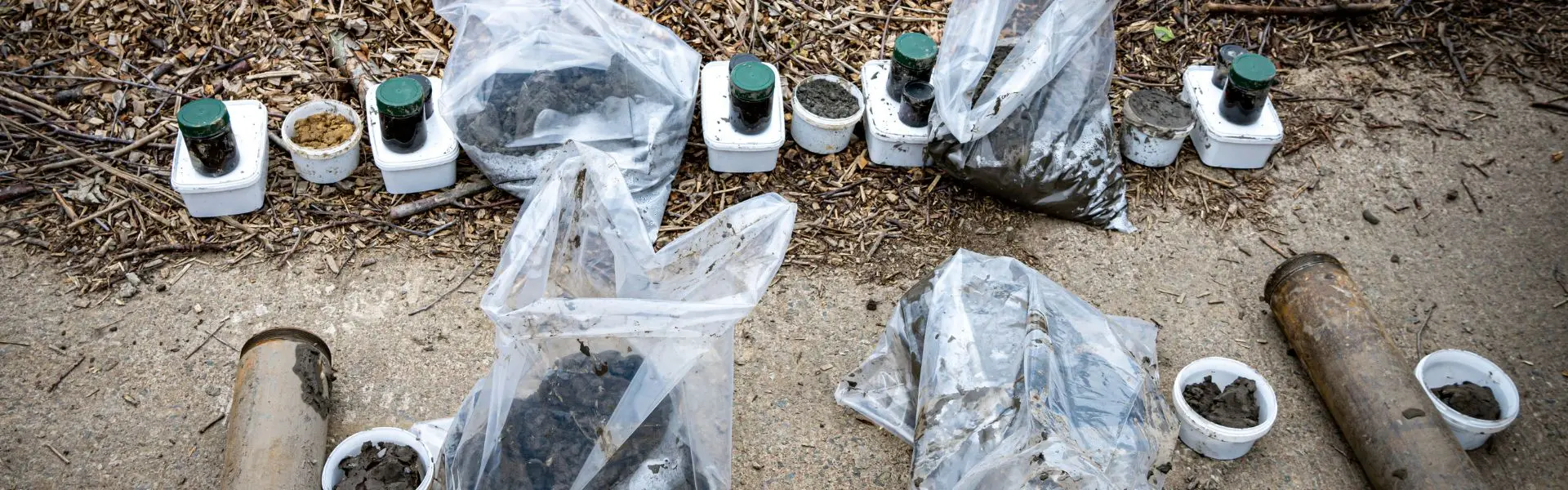
The ground investigation was extensive and included multiple drilling, sampling, and testing methods to fully characterise the ground conditions beneath the site.
- 32 cable percussion boreholes, nine extended by rotary core drilling
- 3 rotary open-hole/core drill-holes
- 22 windowless sample boreholes using a removable liner system
- 1 hand-excavated inspection pit
- In-situ testing, including standard penetration tests (SPTs), permeability testing, photo-ionisation detector (PID) readings, and water quality parameter assessments
- Installation of gas and groundwater monitoring wells
- Groundwater sampling and data-logger installation
- Comprehensive laboratory testing for geotechnical and chemical parameters
- Production of a full factual report
Due to the high density of buried services within the treatment works, a utility mapping survey was undertaken prior to intrusive investigation.
This survey combined electromagnetic and GPR (Ground-Penetrating Radar) techniques to locate and map subsurface utilities and infrastructure.
The results were used to refine exploratory hole locations, ensuring that all drilling and sampling could be undertaken safely and efficiently.
This early-stage risk mitigation exemplified the integrated, multidisciplinary approach that defines Igne’s site investigation capability.
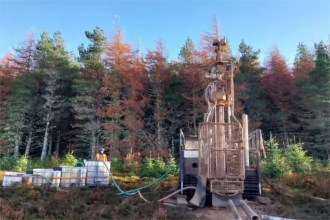
GI Fieldwork and Methodology
Field operations were carried out across three months, followed by post-site monitoring and laboratory testing.
Boreholes were advanced to depths of up to 27.30 metres below ground level (bgl) using cable percussive techniques, with nine extended by rotary coring to depths between 30.00 and 42.20 metres bgl.
Three additional rotary open-hole/core drill-holes were advanced to a maximum depth of 42.50 metres bgl.
Twelve of the windowless sample holes and all thirty-two boreholes were equipped with gas and groundwater monitoring instrumentation. Regular monitoring was conducted after completion of the site works to track gas concentrations and groundwater behaviour.
Groundwater sampling was undertaken from selected installations during two rounds of monitoring. In each case, water quality parameters were recorded for purged water prior to sampling.
Data-loggers installed in three boreholes continuously recorded groundwater level fluctuations beyond the active site period.
Reporting and Deliverables
Following completion of the site operations, in-situ testing, monitoring, and laboratory analysis, Igne compiled a comprehensive factual report detailing the geological, hydrogeological, and geo-environmental conditions encountered.
The report provided the consulting engineer and Northumbrian Water with high-quality, verifiable data to inform foundation design, contamination risk assessment, and infrastructure planning for the site’s future expansion.
The investigation was delivered safely, to programme, and in full compliance with client and consultant specifications.
The integration of utility mapping, drilling, and laboratory analysis ensured a coordinated dataset with minimal risk to buried infrastructure and ongoing site operations.
The resulting factual report provided a clear understanding of ground conditions, supporting the design of an upgraded and more resilient wastewater treatment facility for the region.
Ground Investigation Project Highlights
- Large-scale, multi-method ground investigation on an active utility site
- Advanced GPR utility mapping to mitigate service strike risk
- Boreholes drilled to over 40 metres below ground level
- Comprehensive gas and groundwater monitoring regime
- High-quality factual reporting to support design and environmental compliance
Through integrated investigation, monitoring, and laboratory analysis, Igne provided the robust geotechnical and geo-environmental data required to support safe design and construction at this strategically important site.
Other articles of interest
Ground investigation for a proposed substation Loch Buidhe
Igne was commissioned by SSEN Transmission to undertake the ground investigation at this proposed substation site at Loch Buidhe. The investigations were needed to provide information on the ground conditions for foundation design and construction of the proposed works and in relation to any geochemical contamination of the site.

Strathy South Wind Farm
Igne recently undertook an extensive site investigation project on behalf of SSE Renewables for the Strathy South Wind Farm. This contract spanned 15 weeks and took place in an incredibly environmentally sensitive area of Scotland.